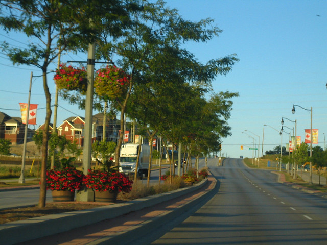
Streetscape Program

York Region has significant planned growth and is investing in creating streets that support its communities and provide people with transportation options within the overall regional transportation network. Streetscape design creates functional, active and vibrant streets that provide facilities for walking, cycling, transit use, recreational use and social interaction. The successful coordination of these elements which fall within public property lines including roads, sidewalks, street trees and gathering spaces create a good public realm. Streetscape creates attractive and safe streets, which are the cornerstone of liveable communities with a distinct sense of place in York Region.
How Streetscape Design in York Region is Implemented Through Policy
Design Objectives
Throughout York Region’s nine municipalities, there are a variety of landscape contexts such as urban centres, suburban communities and rural landscapes. This diversity requires a context-sensitive approach when designing our streets. The following are highlights of York Region’s streetscape design objectives:
- Prioritizing universal accessibility and focusing on pedestrian comfort and safety to encourage walking, cycling, and alternative means of transportation
- Designing for optimum street tree health to improve air quality and reduce energy use
- Applying stormwater management strategies and low-maintenance planting to create sustainable landscapes
- Creating a sense of place by integrating architectural features, public art, street furniture, enhanced paving, and generous planting design
- Clearly defining sidewalks, crosswalks, bicycle lanes and roadways to safely and effectively support multiple modes of transportation
Municipal Streetscape Partnership Program
The Municipal Streetscape Partnership Program (MSPP) is a funding program that assists York Region’s nine local municipalities in cost sharing on streetscape design projects on Regional roads. The Region commits up to $1 million annually towards this program, subject to Regional Council review and approval. This partnership funding program is critical to the success of streetscape design in York Region. The MSPP benefits both local municipalities and York Region in achieving higher quality streetscape design within our communities. Local municipalities are responsible for the operation, maintenance and long term rehabilitation of enhanced streetscape features. Since 2007, York Region has collaborated with local municipalities on the following projects:
How to Apply
MSPP Funding
Under the Municipal Streetscape Partnership Program, there is a defined process, schedule, and submission requirements for leveraging funding.
MSPP Proposal Types with 50% and 33% opportunities
Type 'A' Streetscape Proposal [50%]
- Project is designated as an Urban Area, Town, or Village in the OP and;
- Road construction is on the 10-Year Capital Plan
- Local Municipality undertakes Streetscape improvements that are in alignment with a Regional Capital Project
Type 'B Streetscape Proposal [33%]
- Project is designated as an Urban Area, Town, or Village in the OP and;
- Road construction is NOT on the 10-Year Capital Plan
Application Forms
Policy and Design Guidelines
York Region policies and guidelines define how and where streetscape improvements occur. They provide local municipalities and private developers with standards to create a coordinated and functional public realm, supporting the implementation of streetscape projects that improve our communities one street at a time. These guidelines can range from determining priority areas for improvements, to which elements should be present on six-lane streets, to suitable tree species.
Designing Great Streets Guidelines
Municipal Streetscape Partnership Program Policy - November 2019
Streetscape Design Review Manual
- Streetscape Design Review Manual Executive Summary
- Appendix A: Sight Triangle Manual
- Appendix B: Visual Guide to Streetscape Design
- Appendix C: Streetscape Site Plan Checklist
- Appendix D: Site Plans Examples
- Appendix E: Streetscape Policies and Guidelines Map
- Enhanced Zebra Pavement Marking Detail at Signalized Intersections
- YRT Coordinated Site Furniture Design Guidelines
- Please refer to the Street Tree and Horticultural Design Guidelines and Standards section for Natural Heritage and Forestry resources.
Capital Projects
York Region’s Streetscape Program implements streetscape and master plan policies through Capital projects, which are major projects that improve key regional infrastructure. These projects include road construction and re-surfacing projects, collaboration on vivaNext Rapid Transit projects, York Region Transit, pump houses and odour control facilities. Capital projects are showcased at public consultation sessions to facilitate collaboration with York Region’s residents.
South Yonge Street Corridor Streetscape Master Plan
Yonge Street is York Region’s primary urban corridor and is envisioned to be a distinctive and vibrant urban street that attracts a mix of retail, commercial, housing, employment and recreational uses. The Streetscape Master Plan vision is a bold, sustinable and achievable plan that creates a truly urban street that prioritizes public realm and transit nodes. The Phasing Plan identifies sections along Yonge Street that can be implemented in advance of the Yonge Subway Extension to enable the transformation of Yonge Street.
Streetscape Master Plan Study Update
Phase 1 Report: Research, Inventory and Analysis
Phase 2 Report: Vision
Phase 3 Report: Streetscape Master Plan & Pre-Subway Plan — Report Cover
Phase 3 Report: Table of Contents
Phase 3 Report: 1.0 — Introduction
Phase 3 Report: 2.0 — Conceptual Streetscape Update Options
Phase 3 Report: 3.0 — Draft Master Plan
Phase 3 Report: 4.0 — Pre-Subway Plan
Phase 4A Report: Detailed Design Guidelines
Phase 4B Report: Detailed Design Guidelines and Standards
Phase 5 Report: Implementation Strategy
Phase 6 Report: Executive Summary
Yonge Street and Davis Drive Streetscape Master Plan
Yonge Street and Davis Drive will experience significant growth in the future as Newmarket Centre is one of York Region’s four Regional Centres. By 2031, the area is projected to grow by 20,000 jobs and 21,000 residents, while the Town of Newmarket as a whole will grow to 106,000 residents. This means virtually all population growth in the Town of Newmarket will be concentrated on the Yonge Street and Davis Drive corridors. The Streetscape Master Plan will provide a vision for Yonge Street and Davis Drive within the Town boundaries of Newmarket, excluding the vivaNext section at the intersection of Yonge Street and Davis Drive and along Davis Drive East. The four corridors vary in their current and future built form, and a master plan is required to address the different contexts while maintaining the streetscape vision for the Town of Newmarket.
The Streetscape Master Plan will ensure that future development supports a bold, sustainable and vibrant community. It will provide a seamless transition into the vivaNext streetscape and create streets that will support intensification, mixed-use, and transit-oriented development. York Region and the Town of Newmarket have retained IBI Group to work together and develop the master plan that will focus on:
- Complete streets
- Pedestrian accessibility and comfort
- Outdoor spaces and public art
- Environmentally progressive design
- Variety of spaces and streetscapes
- Place-making
Phase 1 - Yonge Davis Streetscape Master Plan Report Part 1
Phase 1 - Yonge Davis Streetscape Master Plan Report Part 2
Phase 2 - Yonge Davis Streetscape Master Plan Report
Phase 3 - Yonge Davis Streetscape Master Plan Report Part 1
Phase 3 - Yonge Davis Streetscape Master Plan Report Part 2
Phase 4 - Yonge Davis Streetscape Master Plan Report Part 1
Phase 4 - Yonge Davis Streetscape Master Plan Report Part 2
Phase 5 - Yonge Davis Streetscape Master Plan Report
Executive Summary